Abstract
Natural disasters caused by earthquakes can have dire effects on countries, in the form of human casualties/injuries, infrastructure damage, economic and environmental losses. This is particularly true for low-income or developing countries, where a disaster’s economic impact may exceed the country’s own gross domestic income (GDP) leading to a disruption of economic development. Acknowledging this problem, countries worldwide are focused nowadays on assessing the resiliency of their major cities to natural disasters by quantifying the potential consequences, planning disaster response protocols, and developing proper mitigation measures to limit damage.
Egypt’s built environment is largely dated, poorly constructed, and/or under designed. This, coupled with the lack of strong municipal oversight, lead to dangerous practices such as the unauthorized heightening of residential buildings and the use of inadequate construction materials. It is estimated that about half of constructed buildings in Egypt are either unplanned or unlicensed. This makes Egypt’s urban hotspots highly vulnerable to earthquakes. This has been evident from past events including the October 1992 Dahshour earthquake.
The project aims to assess the vulnerability of Egypt’s urban infrastructure under potential earthquake hazard. Focus will be placed on the city of Alexandria. This will include a review of the city’s building stock, particularly residential buildings in its main districts. The building stock will be used to develop a portfolio of archetype buildings that can be then numerical modeled and simulated under hazard-representative earthquake scenarios. The study will help map out the distribution of potential collapses, economic losses, and casualties in Alexandria. This will in turn help in managing the level preparedness and response mechanism, in addition to identifying vulnerable structural types and providing structural solutions to reduce collapse risk and improve resilience.
الملخص
يمكن أن يكون للكوارث الطبيعية الناجمة عن الزلازل آثار وخيمة على البلدان، في شكل خسائر بشرية/إصابات، وأضرار في البنية التحتية، وخسائر اقتصادية وبيئية. وينطبق هذا بشكل خاص على البلدان المنخفضة الدخل أو البلدان النامية، حيث قد يتجاوز التأثير الاقتصادي للكارثة الدخل المحلي الإجمالي للبلد، مما يؤدي إلى تعطيل التنمية الاقتصادية. واعترافاً بهذه المشكلة، تركز البلدان في جميع أنحاء العالم في الوقت الحاضر على تقييم قدرة مدنها الكبرى على الصمود في مواجهة الكوارث الطبيعية من خلال قياس العواقب المحتملة، وتخطيط بروتوكولات الاستجابة للكوارث، وتطوير تدابير التخفيف المناسبة للحد من الأضرار.
إن البيئة المبنية في مصر قديمة إلى حد كبير، وسيئة البناء، و/أو غير مصممة حسب المواصفات. ويؤدي هذا، إلى جانب عدم وجود رقابة بلدية قوية، إلى ممارسات خطيرة مثل الارتفاع غير المصرح به للمباني السكنية واستخدام مواد البناء غير الكافية. تشير التقديرات إلى أن حوالي نصف المباني المشيدة في مصر إما غير مخططة أو غير مرخصة. وهذا يجعل المناطق الحضرية الساخنة في مصر معرضة بشدة للزلازل. وقد ظهر ذلك جلياً من الأحداث الماضية بما في ذلك زلزال دهشور في أكتوبر 1992.
.ويهدف المشروع إلى تقييم مدى ضعف البنية التحتية الحضرية في مصر في ظل مخاطر الزلازل المحتملة. سيتم التركيز على مدينة الإسكندرية. وسيشمل ذلك مراجعة مخزون المباني في المدينة، وخاصة المباني السكنية في مناطقها الرئيسية. سيتم استخدام مخزون المبنى لتطوير مجموعة من المباني النموذجية التي يمكن بعد ذلك تصميم نماذج رقمية ومحاكاتها في ظل سيناريوهات الزلازل التي تمثل المخاطر. وستساعد الدراسة في تحديد توزيع الانهيارات المحتملة والخسائر الاقتصادية والخسائر في الإسكندرية. وهذا بدوره سيساعد في إدارة مستوى الاستعداد وآلية الاستجابة، بالإضافة إلى تحديد الأنواع الهيكلية الضعيفة وتقديم الحلول الهيكلية للحد من مخاطر الانهيار وتحسين المرونة.
Project Team

Work Packages
WP #1: Built-environment mapping
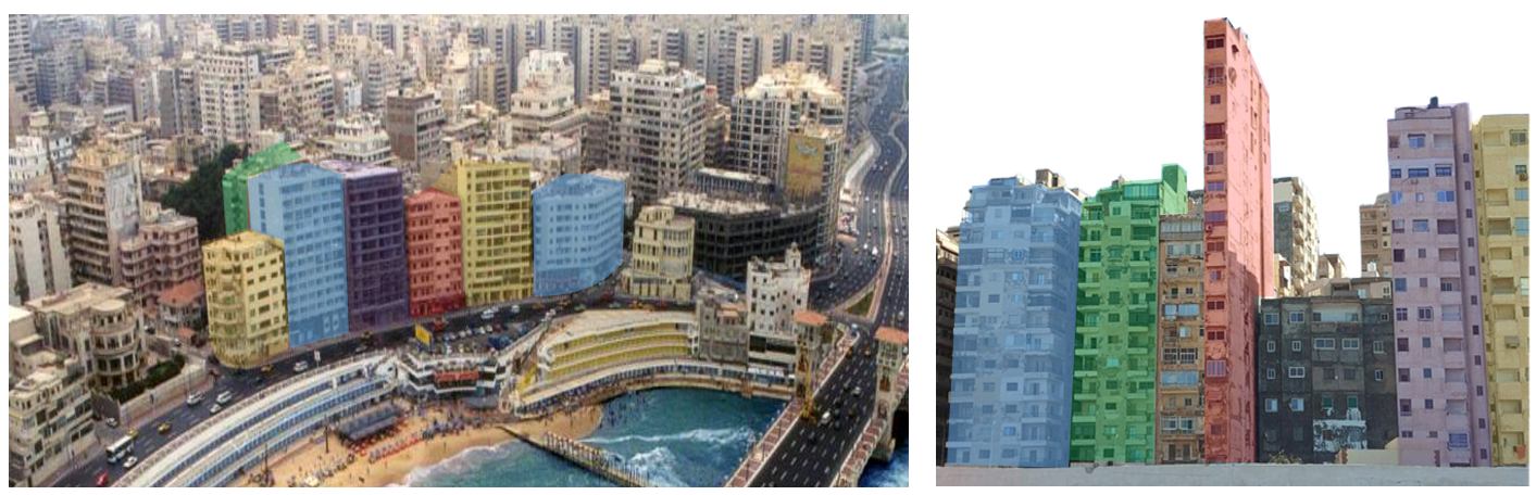
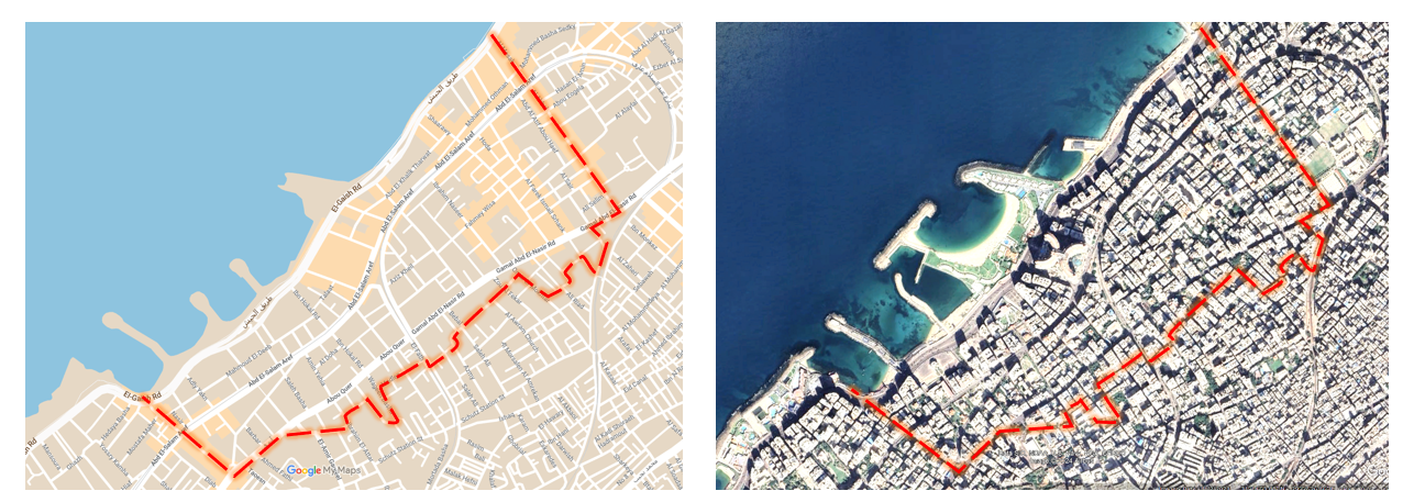
This workpackage is lead by UrbanLab, Alexandria University aims to developing a GIS database for the urban environemt. This will include a review of the building stock, particularly residential buildings. Data will be collected related to construction date, building dimensions/height, structural system, foundations, etc. The data will be collected from available satallite images, digital maps, city data, local design firms, and finally field surveying. The building stock will be used to develop a portfolio of archetype buildings that can then be modeled and simulated under representative earthquake scenarios.
Focus will be placed on the city of Alexandria. The initial zone of interest is about 1.25 km2 and falls within Sharq district. The zone is bounded by the Cornich street in the north, Abu-Quer street in the south, Ikbal street in the east to Mostafa Fahmi street in the west.
This workpackage has concluded. See output here.
WP #2: Archetype building portfolio
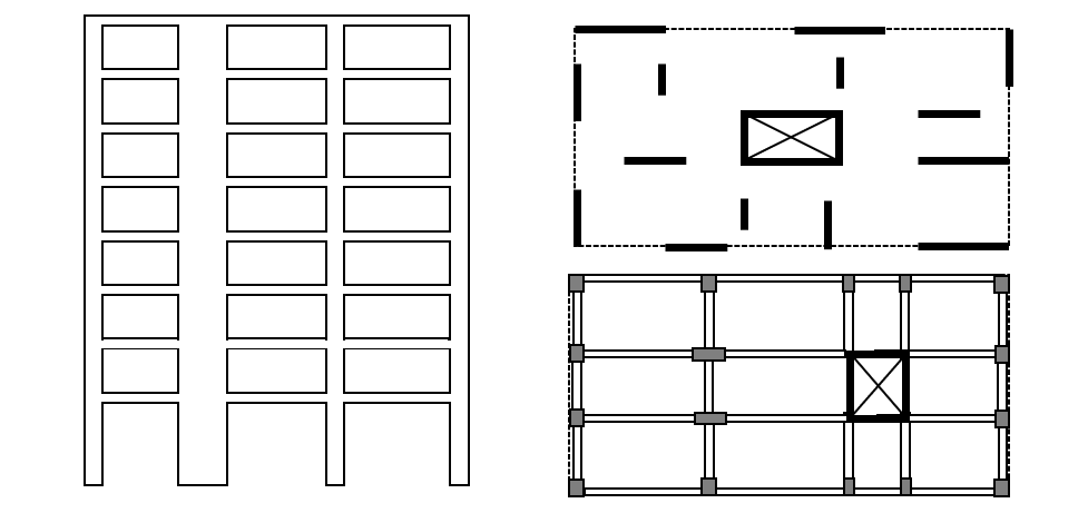
This work package will involve the development of archetype residential buildings representative of the building portfolio in the studied zone. This will be achieved through statistical analysis and clustering techniques to identify the distribution of architectural, structural, and geotechnical properties of the residential building stock. The archetype buildings will be mainly characterized by the date of construction/design, number of stories, structural system, floor area, and number of columns per unit area.
WP #3: Seismic hazard analysis
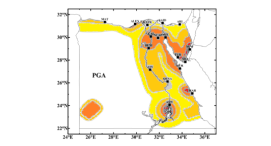
This work package will involve an assessment of the seismic hazard in Alexandria. An updated seismic source model will be developed for Egypt, considering historical seismic information, active faults, and associated uncertainty with an emphasis on seismic sources that affect Alexandria. Neo-deterministic seismic hazard assessment (NDSHA) will be carried out using the updated seismic source model. In this WP, the ground-motion time series will be defined on the bedrock as the envelope of ground shaking at the site. To further delineate the NDSHA results, geological soil layer maps will be used to conduct seismic microzonation to assess the local site effects based on the VS30 classification. The generated suite of synthetic ground motion records will be used in consequent structural analysis.
WP #4: Structural analysis
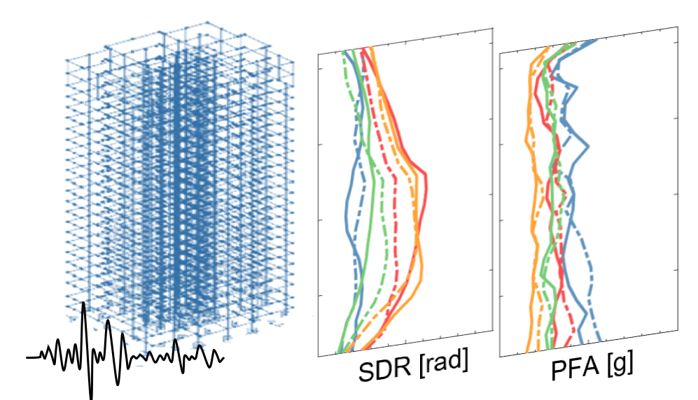
This work package will involve the development of state-of-the-art 3-dimensional numerical models of the archetype buildings and conducting nonlinear dynamic response-history analysis using a suite of ground motions. The analysis will be used to quantify key engineering demand parameters such as story drifts and floor accelerations.
WP #5: Risk and loss quantification
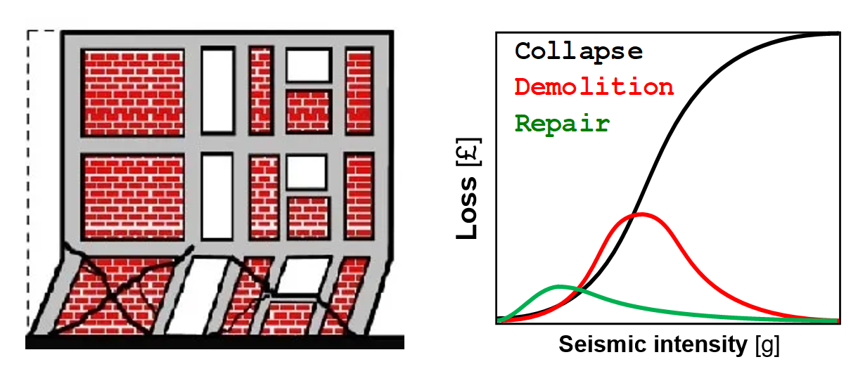
In this work package, the EDPs will be used to quantify the probability of sidesway global or progressive collapse. In the case of no collapse, the response will be assessed in terms of the expected structural and non-structural damages and their associated consequences which include monetary losses and human injuries and casualties. By linking the estimated losses with the GIS maps, the geographic distribution of potential human and materials losses will be mapped.
WP #6: Mitigation measures
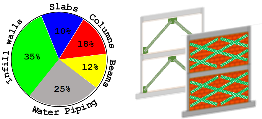
This work package will assess the different loss metrics and use them to highlight vulnerable building portfolios. The high-resolution loss analysis will help us identify specific structural and/or non-structural components that contributes the most to losses. The aim is to draw the attention of decision-makers, stakeholders, and governmental agencies to these vulnerabilities and risk drivers within the building stock. Recommendations will accordingly be developed for disaster risk mitigation. These will be in the form of 1) ideal structural systems and design guidelines, and 2) practical and feasible structural retrofitting measures that adhere to local construction practice (e.g., column jackets, masonry wall strengthening, etc.).
How can you contribute to Egypt-SeReAM activities?
There are many ways you can contribute to Egypt-SeReAM activities whether you work in academia, industry, or municiplaity. This includes contributions to research (data collection, expert feedback, etc) or networking (workshops, seminars, and training events) activitieis. If interested, please fill this form